
Maps
These 19th century maps and map publishers are mentioned in Thoreau's “The Maine Woods”.
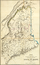
Left: Map of the principal rivers, mountains and highland ranges of the State of Maine, by Moses Greenleaf. 1828. Engraved by Wm. Chapin, New York for Greenleaf's survey of Maine. Published by Shirley & Hyde, Portland, 1829. Click image for zoomable version and more information.
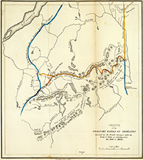
Right: Sketch of the imaginary ranges of highlands. Reported by the British surveyors under the Treaty of Ghent, as extending across the State of Maine. (By Moses Greenleaf). W. Chapin Sculpt. New York. (Portland, published by Shirley & Hyde, 1829). Click image for zoomable version and more information.
Above maps are from the Atlas accompanying Greenleaf's map and statistical survey of Maine. Portland. Shirley & Hyde. 1829.
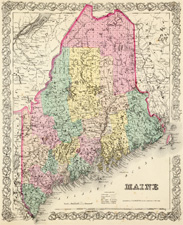
Maine. Published by J.H. Colton & Co. 172 William St. New York. Entered 1855 by J.H. Colton & Co. New York. No. 9. Click image for zoomable version. From Colton's Atlas Of The World, Illustrating Physical And Political Geography. By George W. Colton. Accompanied By Descriptions Geographical, Statistical, And Historical, By Richard Swainson Fisher, M.D. Complete In One Volume. New York: J.H. Colton And Company, No. 172 William, Corner Beekman Street. 1856.
View all three of the above images together as zoomable versions along with more information at the David Rumsey Historical Map Collection.
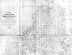
Plan of the Public Lands of the State of Maine, Surveyed under Instructions from the Commissioners & Agents of the States of Massachusetts and Maine. Copied from the original surveys on a reduced scale & corrected by Geo. W. Coffin, Land Agent of the Commonwealth of Massachusetts. 1st August, 1835.
Thoreau wrote that he carried a copy of this map with him on his excursions.
For more information and a detailed view of this map, click image or see 1835 Map of the Public Lands of Maine, Historical Maps, Upper St. John River Valley.
Links to more maps, online exhibitions and map collections:
- Thoreau – Wabanaki Trail
- The Cartographic Creation of New England, USM, Osher Map Library, Smith Center for Cartographic Education
- Maine Wilderness Transformed—Timber, Sporting, and Exploitation of the Moosehead Lake Region, USM, Osher Map Library, Smith Center for Cartographic Education
- The Shape of Maine, Maine Memory Network
- Moses Greenleaf and the Maine Wilderness
- Historic USGS Maps of New England & NY, UNH Library, Government Information Dept.
- David Rumsey Historical Map Collection